
Search and rescue teams face a critical choice: respond slowly with limited visibility, or deploy unmanned aerial search missions that cover ground in minutes instead of hours.
At IE Drone Services, we’ve seen firsthand how coordinated drone operations change outcomes. The right equipment, communication protocols, and flight planning separate successful rescues from missed opportunities.
How Drones Outpace Traditional Search Methods
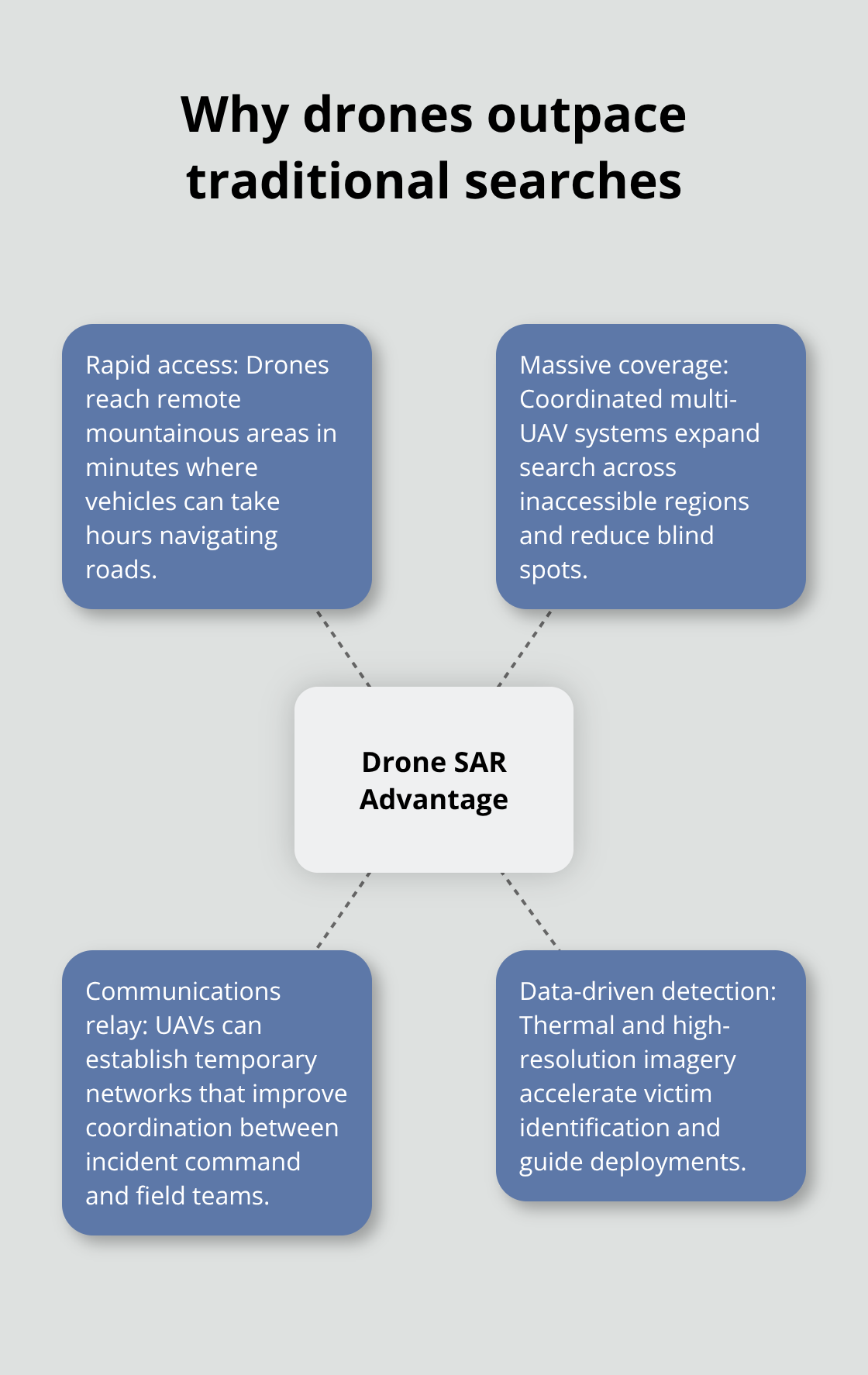
Drones eliminate the response lag that costs lives in search and rescue. A preliminary drone search locates lost hikers alive within about two hours across more than 1,000 acres, according to real-world SAR data. Traditional ground teams covering the same terrain require days. Drones reach remote mountainous areas in minutes where vehicles would take hours navigating roads. The coverage advantage proves staggering: a coordinated multi-UAV system expands search coverage across inaccessible regions while establishing temporary communications networks, and dedicated UAV systems achieve around 80 percent victim identification in mountainous disaster scenarios. Battery endurance and payload capacity determine real-world coverage limits. High-elevation SAR missions face increased battery drain and reduced performance, requiring careful planning with extra margins and cautious speeds.
A sample SAR mission covered four zones totaling roughly 277 acres at elevations between 11,200 and 13,100 feet, achieving complete coverage in about six hours with no re-flights. That efficiency matters because every hour counts when someone is missing.
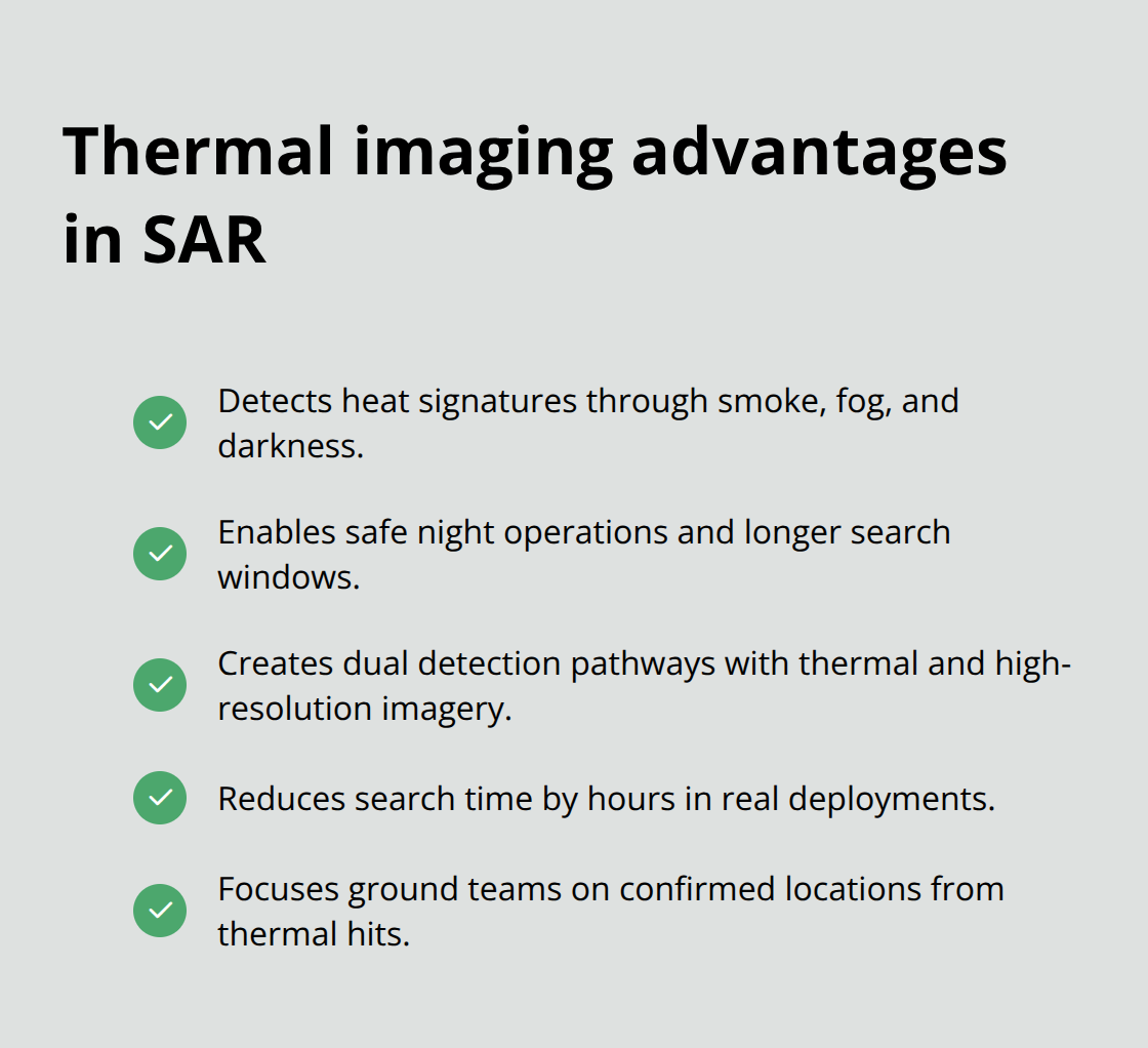
Thermal Imaging Cuts Search Time Significantly
Thermal imaging transforms what drones detect. Infrared cameras enable rapid victim location in dense forests and during night operations by detecting heat signatures through smoke, fog, or darkness. This capability alone justifies drone deployment because ground teams searching at night with flashlights miss victims that thermal sensors spot instantly. Real-time video streams to incident command improve situational awareness and coordinated decision-making, allowing commanders to prioritize resources based on actual conditions rather than assumptions. High-resolution imagery (such as 20-megapixel sensors) enhances post-flight object recognition and detail for SAR analysis, enabling continued search after flights when analysts review footage methodically. Drones share private live feeds of emergencies with headquarters to inform immediate decisions. The combination of live thermal data and high-resolution imagery creates multiple detection pathways that ground teams cannot replicate.
Terrain Mapping Informs Every Decision
Terrain-aware autonomous SAR missions maintain terrain-relative altitude, improving safety and search accuracy in rugged high-elevation areas. Importing high-resolution terrain data from USGS 1-meter LiDAR digital elevation models creates accurate terrain maps for offline planning, enabling SAR missions without internet connectivity in remote zones. Offline workflows and lack of live network access increase resilience for SAR teams operating in genuinely remote areas where connectivity fails. Coordinated multi-drone operations double coverage and shorten mission duration for large search zones through centralized control that assigns routes per drone, minimizing overlaps and gaps for complete area coverage. Field-adaptable flight areas enable on-the-fly adjustments to search zones as new information becomes available, transforming rigid plans into responsive operations. Terrain-following automation sustains consistent altitude across uneven terrain, reducing risk and improving data quality (a precision that separates hasty, incomplete searches from methodical operations).
Coordinated Planning Eliminates Blind Spots
Planned route overlaps and gaps visibility provides confidence of full coverage and aids post-mission data stitching. Centralized multi-pilot control yields greater efficiency and safer, more reliable SAR operations than fragmented tools. Coordinated, terrain-aware planning and multi-drone coordination collectively improve the chances of locating subjects quickly. Organizations that establish these protocols before emergencies strike respond faster when lives depend on it. The next section examines how to build communication systems and flight patterns that transform coordination from theory into practice.
Planning and Coordinating Effective Drone Search Missions
Establish Communication Protocols Before Emergencies Strike
Communication protocols separate functional search missions from chaotic ones. Ground teams and drone pilots must establish clear chains of command, frequency assignments, and handoff procedures weeks before deployment becomes necessary. Without this structure, drone footage arrives at headquarters while ground teams search blind areas already covered.
Assign one person as the drone coordinator who speaks directly to incident command and translates strategic priorities into flight assignments. Real-time video streams to incident command improve situational awareness and coordinated decision-making, but only if someone actively monitors and interprets that feed. Establish radio protocols that prevent pilots from becoming distracted by ground team chatter. Designate specific frequencies for drone operations separate from general dispatch traffic.
Test these communication systems during training exercises, not during actual emergencies. Teams that practice coordination protocols respond faster when real incidents occur because pilots and commanders already understand each other’s language and expectations.
Map Search Grids with Precision
Flight planning demands precision that most organizations underestimate. Map search grids using high-resolution terrain data imported from USGS one-meter LiDAR digital elevation models before missions launch, enabling complete offline planning for areas without cellular coverage. Divide large search zones into manageable segments where each drone covers one grid systematically, minimizing overlaps that waste battery and gaps that leave blind spots.
Centralized multi-pilot control through a single planning tool yields greater efficiency than fragmented operations where pilots coordinate ad hoc. This approach ensures that all team members work from the same flight plan and understand their assigned coverage areas. High-resolution imagery (such as 20-megapixel sensors) enhances post-flight object recognition and detail for SAR analysis, enabling continued search after flights when analysts review footage methodically.
Account for Weather and Environmental Constraints
Weather conditions determine whether drones fly or remain grounded, and many teams ignore this reality until mid-mission equipment failures occur. High winds above 20 knots degrade thermal imaging accuracy and reduce flight endurance significantly. Rain and fog eliminate infrared advantages entirely because water droplets block heat signatures.
Try early morning operations when winds typically remain calm and thermal contrast between warm subjects and cold ground peaks. This timing maximizes the effectiveness of thermal sensors and extends battery life through reduced wind resistance. Adverse weather and extreme temperatures degrade flight performance and stability, necessitating weather-aware planning and contingencies before launch.
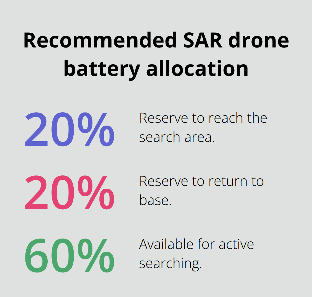
Plan Battery Reserves with Ruthless Honesty
Battery planning requires ruthless honesty about margins. Allocate 20 percent battery reserve to reach the search area, another 20 percent to return to base, and operate the remaining 60 percent within the actual search zone. High-elevation terrain drains batteries faster, so reduce search area estimates by 15 to 20 percent at elevations above 10,000 feet.
Missions that ignore these constraints end with drones landing in remote terrain or returning with incomplete coverage, forcing expensive and dangerous recovery operations. A sample SAR mission covered four zones totaling roughly 277 acres at elevations between 11,200 and 13,100 feet, achieving complete coverage in about six hours with no re-flights. That efficiency matters because every hour counts when someone is missing, and incomplete coverage forces teams to restart searches or expand operations into uncertain terrain.
The next section examines the specific technologies and equipment that transform coordinated plans into successful rescue outcomes.
Technology and Equipment for Search Operations
Thermal Imaging Detects Heat Signatures Ground Teams Miss
Thermal imaging separates drones that find people from drones that waste time. Infrared cameras detect heat signatures through smoke, fog, and darkness-conditions where ground teams with flashlights miss victims entirely. The technology works because human bodies emit infrared radiation that thermal sensors capture instantly, even when visual light fails completely. Night operations become viable with thermal imaging, extending search windows beyond daylight hours when missing persons often move or signal for help. The 20-megapixel high-resolution cameras paired with thermal sensors create dual detection pathways-thermal catches heat signatures in real-time while high-resolution imagery enables analysts to review footage methodically after flights, catching details that live monitoring misses. Real-world search and rescue deployments show that thermal imaging reduces search time by hours because responders stop guessing about where to deploy ground teams and instead focus on confirmed locations where thermal data identified heat sources.
GPS Autonomy and Terrain Navigation Prevent Crashes
GPS navigation and flight autonomy determine whether search missions cover planned areas or become pilot exercises in manual control. Terrain-relative altitude automation maintains consistent height above uneven ground, preventing drones from crashing into hillsides while ensuring consistent image quality across elevation changes. Importing high-resolution terrain data from USGS one-meter LiDAR digital elevation models before missions enables complete offline planning in areas without cellular coverage-critical because remote search zones often lack network connectivity. Coordinated multi-drone operations with centralized control eliminate overlapping flight paths and coverage gaps that plague ad-hoc operations, doubling search efficiency when two drones work from the same flight plan rather than competing for airspace.
Battery Reserves Determine Mission Success or Failure
Battery reserves determine mission success or failure, yet most teams plan inadequately. Allocate 20 percent battery to reach the search area and another 20 percent to return to base, leaving only 60 percent for actual searching. High-elevation terrain above 10,000 feet drains batteries 15 to 20 percent faster than sea-level operations, so reduce search area estimates accordingly. A sample mission covering four zones totaling 277 acres at elevations between 11,200 and 13,100 feet achieved complete coverage in six hours with no re-flights because planners respected battery constraints rather than ignoring them. Missions that violate these margins end with incomplete coverage, forcing teams to restart searches or conduct expensive recovery operations in dangerous terrain. Adverse weather and extreme temperatures accelerate battery drain, making morning operations preferable when temperatures stabilize and wind remains calm.
Final Thoughts
Unmanned aerial search missions succeed when organizations commit to three fundamentals: thermal imaging that detects what ground teams cannot see, coordinated flight planning that eliminates coverage gaps, and battery reserves that prevent incomplete searches. The data proves this approach works-dedicated UAV systems achieve around 80 percent victim identification in mountainous disaster scenarios, and preliminary drone searches locate lost hikers alive within two hours across more than 1,000 acres. Ground teams cannot match that speed or coverage.
Professional coordination transforms drone capability into rescue outcomes. Teams that establish communication protocols before emergencies strike respond faster when lives depend on it. Centralized multi-pilot control prevents the chaos of fragmented operations where pilots work without shared flight plans, and terrain-aware planning using high-resolution USGS data enables complete offline operations in remote areas where cellular networks fail.
We at IE Drone Services operate as an FAA-certified drone company in the Inland Empire equipped with DJI platforms, high-resolution cameras, and infrared sensors specifically designed for search-and-rescue operations. Our heat-sensing searches deliver faster response times and precise data that ground teams use to deploy resources effectively. Contact IE Drone Services to discuss how coordinated unmanned aerial search missions can transform your emergency response capability and save lives in your region.