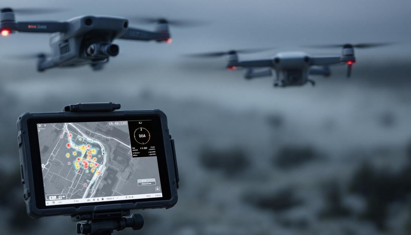
Every second counts when lives are at stake. Emergency thermal search operations leverage infrared technology to locate missing persons, assess disaster zones, and guide rescue teams with precision that ground-based methods cannot match.
Thermal imaging cuts through darkness, smoke, and poor visibility to detect heat signatures in real time. This capability transforms how emergency responders operate, enabling faster decisions and broader coverage in the moments that matter most.
How Thermal Imaging Detects What Eyes Cannot
Heat Signatures That Darkness Cannot Hide
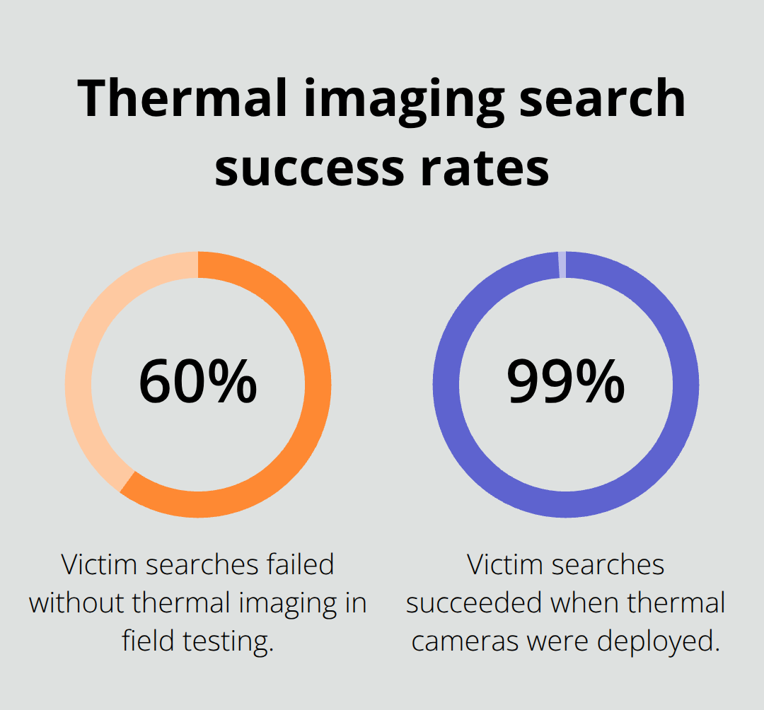
Thermal imaging operates on a fundamental principle that separates it from conventional search methods: it detects infrared radiation emitted by all objects, not reflected light. A missing person’s body temperature around 98.6°F creates a distinct heat signature that stands out sharply against cooler surroundings, even when darkness, smoke, or dense vegetation eliminates visibility entirely. This capability delivers an immediate tactical advantage. Fire-Rescue Magazine’s 1999 field study found that without thermal imaging, 60% of victim searches failed, while 99% succeeded with thermal cameras deployed.
More recently, the Johnson City Fire Bureau documented victim-search times dropping from 8 minutes 38 seconds to 3 minutes 30 seconds when thermal imaging was deployed-a 60% reduction that directly translates to lives saved in time-critical moments.
Penetrating Smoke and Fog Where Other Technologies Fail
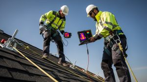
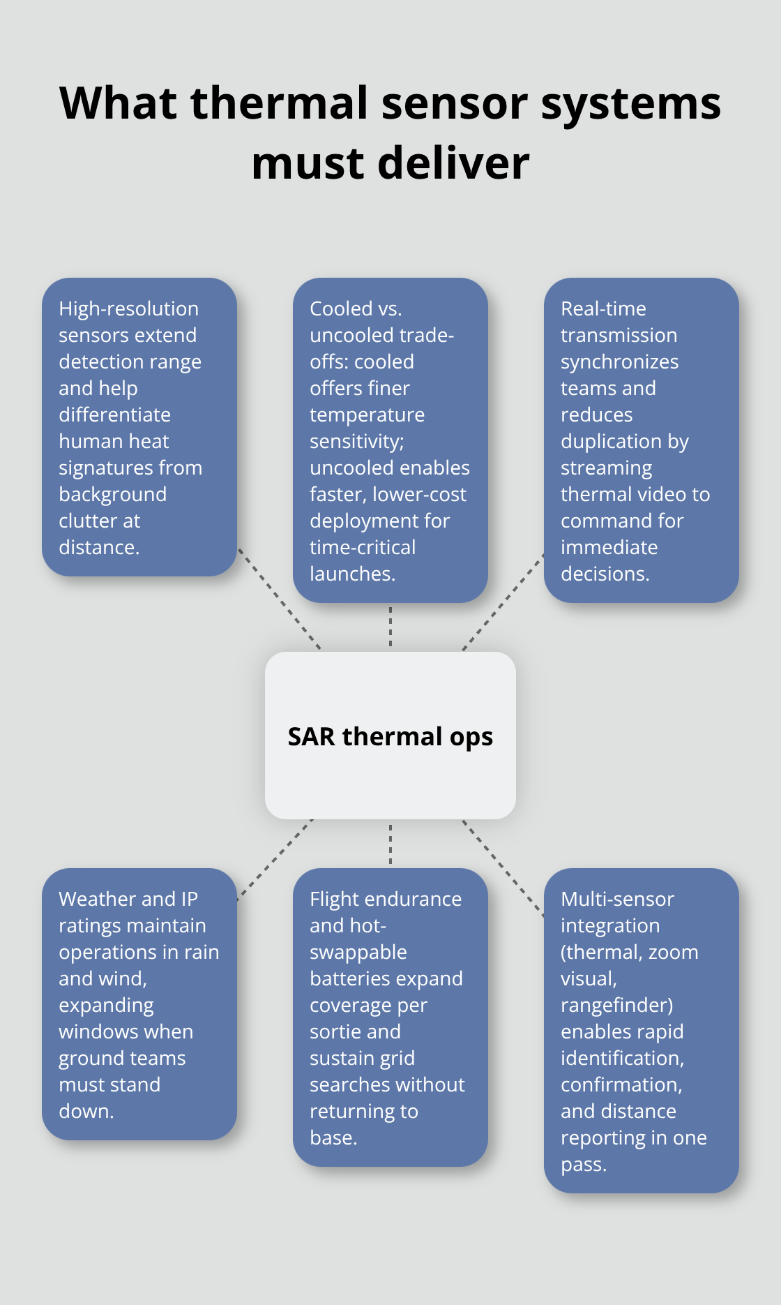
Thermal cameras penetrate smoke and fog that render standard night-vision and visible-light cameras useless, making them indispensable in wildfire rescues, structure fires, and water rescues in fog. DHS field testing confirms that drones equipped with thermal sensors act as force multipliers for first responders, delivering situational awareness within minutes of dispatch rather than hours. Resolution matters significantly here: a 1280×1024 thermal sensor captures fine detail at extended ranges, enabling operators to differentiate human heat signatures from background clutter in urban environments, whereas lower-resolution 640×512 sensors suit rapid-deployment scenarios where speed outweighs precision.
Real-Time Intelligence That Accelerates Command Decisions
The real impact emerges in decision-making velocity. When incident commanders receive real-time thermal video feeds, they direct ground teams with spatial accuracy impossible from ground-level communication alone. This eliminates wasted search efforts in wrong zones and concentrates resources where they generate results. Weather resistance compounds this advantage: platforms rated IP55 or higher continue operating in rain and wind that ground teams cannot navigate safely, expanding the window for successful rescue operations when conditions deteriorate rapidly.
These detection capabilities form the foundation for how thermal drones transform search operations across diverse emergency scenarios, from urban collapses to wilderness rescues.
What Thermal Sensors Deliver in Emergency Operations
Sensor Resolution and Detection Range
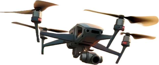
Thermal drone systems deliver measurable performance advantages that separate emergency response into two operational categories. The sensor hardware determines detection capability. A 1280×1024 thermal camera on platforms like the DJI Matrice 350 RTK penetrates smoke and darkness to detect human heat signatures at distances exceeding 9,800 feet, enabling commanders to locate missing persons across sprawling terrain in minutes rather than hours. Lower-resolution 640×512 sensors sacrifice detection range but weigh far less, making them ideal for rapid-deployment scenarios where teams must launch within seconds of dispatch. Thermal resolution and thermal sensitivity determine whether operators can distinguish a human from background heat. Higher resolution improves detail at extended ranges, critical in wilderness rescues where targets appear small on screen. Lower resolution forces operators closer to subjects, reducing search efficiency.
Cooled Versus Uncooled Systems and Flight Endurance
The choice between cooled and uncooled thermal cameras determines operational reality. Cooled systems detect finer temperature variations and deliver superior range, while uncooled cameras cost significantly less and deploy faster. For time-critical SAR operations, uncooled platforms often win because speed of launch outweighs marginal detection improvements. Flight endurance directly impacts search coverage. The DJI Matrice 350 RTK achieves 55-minute flight times, allowing teams to scan 40 to 60 acres per sortie depending on altitude and grid density. Carry multiple batteries-this is non-negotiable. A single battery limits you to one search pass; backup power enables comprehensive area coverage without returning to base.
Real-Time Transmission and Weather Resilience
Real-time video transmission separates functional systems from lifesaving ones. Streaming thermal footage directly to incident command centers enables immediate ground-team coordination without radio delays or operator interpretation errors. Platforms with integrated real-time transmission (such as DJI FlightHub 2 fleet management) allow multiple teams to view identical thermal feeds simultaneously, eliminating duplicate search efforts and directing resources to confirmed target locations. Weather resistance ratings determine operational windows. IP67-rated systems continue operating in rain and wind; lower ratings restrict deployments to calm conditions. IP67 is the practical minimum for emergency response because weather deteriorates rapidly during rescue operations.
Operating temperature ranges matter equally: systems rated for minus-4°F to 122°F function across seasons and extreme conditions, while narrower ranges fail precisely when rescue operations intensify.
Thermal Drones Versus Ground-Based Search Methods
Traditional ground-based searches waste resources systematically. A team searching a 20-acre structure fire or flood zone on foot covers perhaps one acre per hour in low visibility, missing victims in adjacent zones. A thermal drone covers the same area in under five minutes, delivering precise coordinates to ground teams. Chicago Fire Department testing showed locating a downed firefighter dropped from 4 minutes 30 seconds without thermal imaging to 2 minutes 15 seconds with thermal drones-a 50% reduction that translates directly to survival probability. Thermal drones eliminate the disorientation that injures and kills rescuers. Firefighters equipped with thermal imaging and proper training exit structures 100% of the time according to field research, versus significantly lower success rates in zero-visibility conditions.
Multi-Sensor Integration for Rapid Confirmation
Multi-sensor payloads amplify operational advantage by combining thermal cameras with high-resolution visual feeds, zoom optics, and laser rangefinders. This integration eliminates secondary confirmation steps: operators identify thermal targets, zoom to visual confirmation, and report exact distance in a single operation rather than cycling between tools. These capabilities establish the foundation for how thermal systems perform across specific emergency scenarios, from urban collapses to wilderness rescues to active fire operations.
Where Thermal Drones Deliver Real Rescue Results
Wilderness Search Operations That Compress Hours Into Minutes
Thermal drones locate missing persons in wilderness terrain within minutes, transforming emergency response by delivering actionable intelligence within minutes of dispatch. Missing person searches illustrate this difference starkly. A ground team searching a 40-acre forest covers perhaps two acres per hour in low visibility, leaving vast zones unchecked as daylight fades. A thermal drone covers the same 40 acres in under eight minutes, transmitting heat signatures directly to incident commanders who direct ground teams to exact GPS coordinates. The Ponchatoula, Louisiana case demonstrates this capability: a thermal drone located a missing child at dawn, illustrating the difference between hours of fruitless ground searching and minutes of aerial thermal coverage.
Wildfire Operations and Firefighter Safety
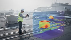
Wildfire operations reveal equally dramatic advantages. CAL FIRE and Austin Fire Department crews deploy thermal drones to map fire perimeters and identify hotspots that ground teams cannot access safely, enabling command staff to position resources before flames advance. A 1280×1024 thermal sensor on a platform like the DJI Matrice 350 RTK detects heat signatures through smoke at distances exceeding 9,800 feet, giving firefighters situational awareness that prevents disorientation and unsafe positioning. The data justifies investment directly: firefighter disorientation causes significant fireground injuries according to NFPA analysis, and thermal imaging reduces this risk by providing clear visual reference in zero-visibility conditions.
Post-Disaster Assessment in Structural Collapse
Post-disaster assessment after structural collapse demands speed and precision that ground-level inspection cannot provide. Following the 2023 Turkey-Syria earthquake, thermal drones located survivors in rubble by detecting human body heat beneath concrete and debris, guiding rescue teams to extraction points faster than visual inspection alone. These operations share a critical requirement: real-time thermal video transmission to command centers eliminates delays caused by operator interpretation or radio communication gaps. Platforms with integrated fleet management (such as DJI FlightHub 2) allow multiple teams to view identical thermal feeds simultaneously, preventing duplicate search efforts and concentrating resources where targets are confirmed.
Weather Resilience and Extended Operational Windows
Weather resistance rated IP55 or higher ensures operations continue when ground conditions deteriorate, extending the operational window precisely when rescue probability peaks. Thermal drones execute in minutes what ground teams require hours to accomplish, and this speed differential determines survival outcomes in time-critical operations.
Final Thoughts
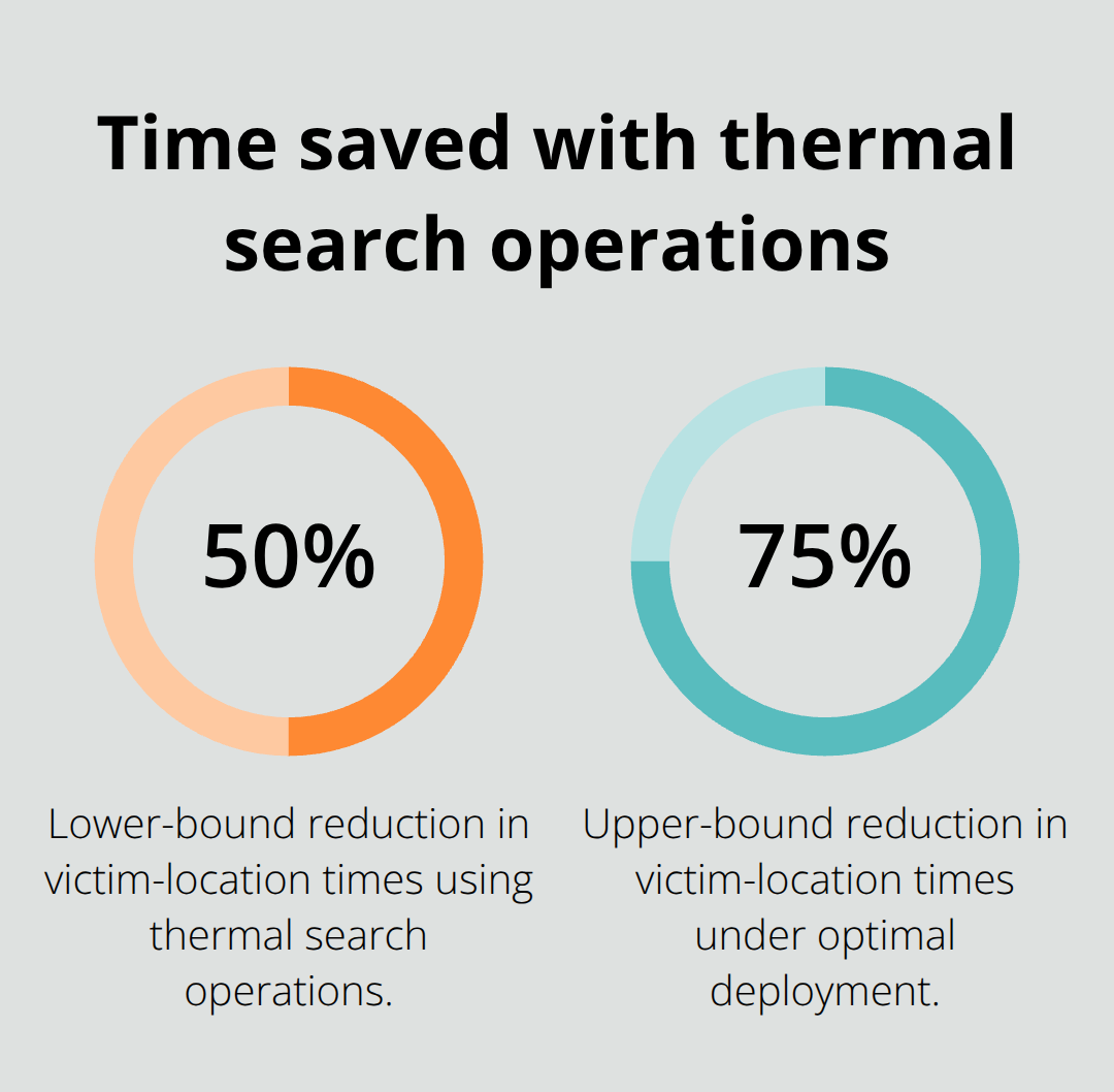
Emergency thermal search operations reduce victim-location times by 50 to 75 percent compared to ground-based methods alone, directly translating detection speed into survival probability. When incident commanders receive real-time thermal feeds, they eliminate wasted search efforts in wrong zones and concentrate resources where they generate measurable results within minutes of dispatch.
Wilderness rescues compress hours of ground searching into minutes of aerial coverage, wildfire operations provide situational awareness that prevents firefighter disorientation, and post-disaster assessment after structural collapse guides rescue teams to survivors faster than visual inspection alone.
For agencies considering thermal drone integration, define your primary mission profile first-rapid-deployment scenarios favor compact uncooled systems like the DJI Mavic 3 Thermal, while large-area wilderness searches justify the extended range of cooled platforms like the DJI Matrice 350 RTK. Prioritize real-time transmission capability and multi-sensor payloads that combine thermal imaging with high-resolution visual feeds and laser rangefinders. Invest in operator training that includes thermal interpretation and SAR tactics to maximize equipment effectiveness.
The competitive advantage belongs to agencies that deploy thermal drones as integrated systems rather than standalone tools. Vertical integration between hardware, software, and training reduces compatibility issues and improves reliability when lives depend on performance. Start with a pilot program in your highest-risk operational area, document outcomes, and scale based on demonstrated results.