When a person goes missing, every minute counts. Multi-drone search coordination has transformed how rescue teams locate missing persons, covering vast areas in hours instead of days.
At IE Drone Services, we’ve seen firsthand how coordinated aerial assets dramatically improve recovery outcomes. This guide shows you exactly how modern drone technology works in real search and rescue operations.
How Multi-Drone Teams Cover Ground Faster
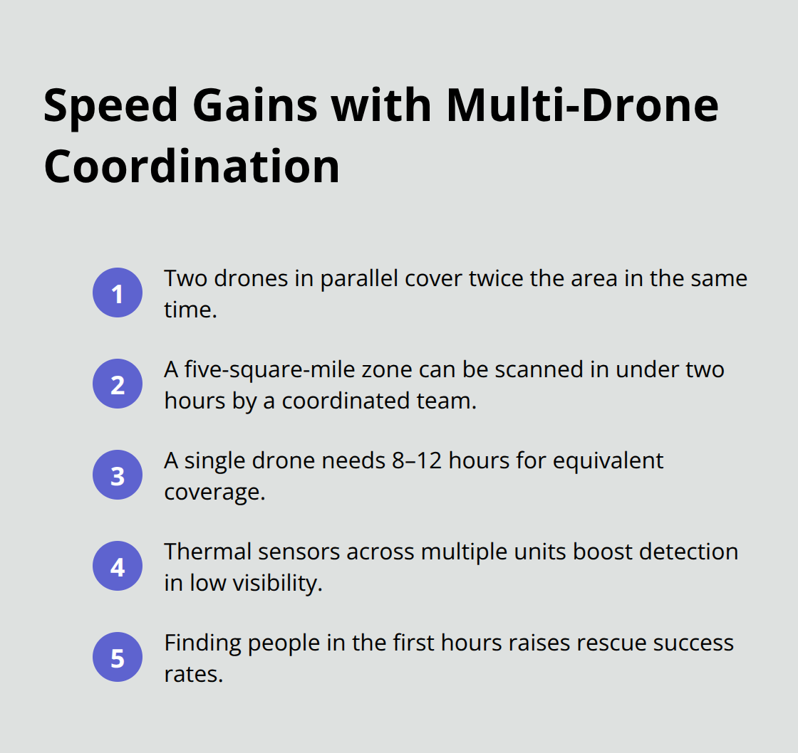
Multi-drone coordination transforms search areas from impossible to manageable. When coordinated effectively, multiple drones cover ground simultaneously rather than sequentially, compressing search timelines dramatically. Research shows that coordinated multi-UAV systems expand search coverage and speed up victim localization significantly compared to single-drone operations. The practical advantage is straightforward: two drones working in parallel cover twice the area in the same time, while thermal imaging capabilities across multiple units increase detection accuracy in low-visibility conditions like smoke, dust, or darkness. A coordinated team scans a five-square-mile wilderness area in under two hours, whereas a single drone requires eight to twelve hours for equivalent coverage. This speed difference directly impacts survival rates-studies consistently show that locating missing persons within the first few hours increases rescue success substantially.
Thermal Imaging Detects What Others Miss
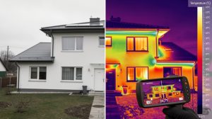
Thermal cameras on coordinated drones detect body heat signatures that visible-light cameras miss entirely. When multiple drones carry thermal sensors and share real-time data, rescuers receive immediate confirmation of survivor locations rather than waiting for image analysis. Multi-sensor integration including infrared imaging enhances detection capabilities and enriches situational awareness for rescue teams on the ground. A thermal-equipped drone locates a missing person in dense forest, rocky terrain, or rubble within minutes of deployment, whereas ground teams searching the same area manually require hours or days. The key is coordination-when one drone detects a heat signature, it communicates that location to team members and ground control simultaneously, enabling rapid dispatch of rescue personnel. This real-time data sharing eliminates delays that occur when rescuers wait for a single drone to return, download footage, and process images.
Decentralized Control Prevents Operational Bottlenecks
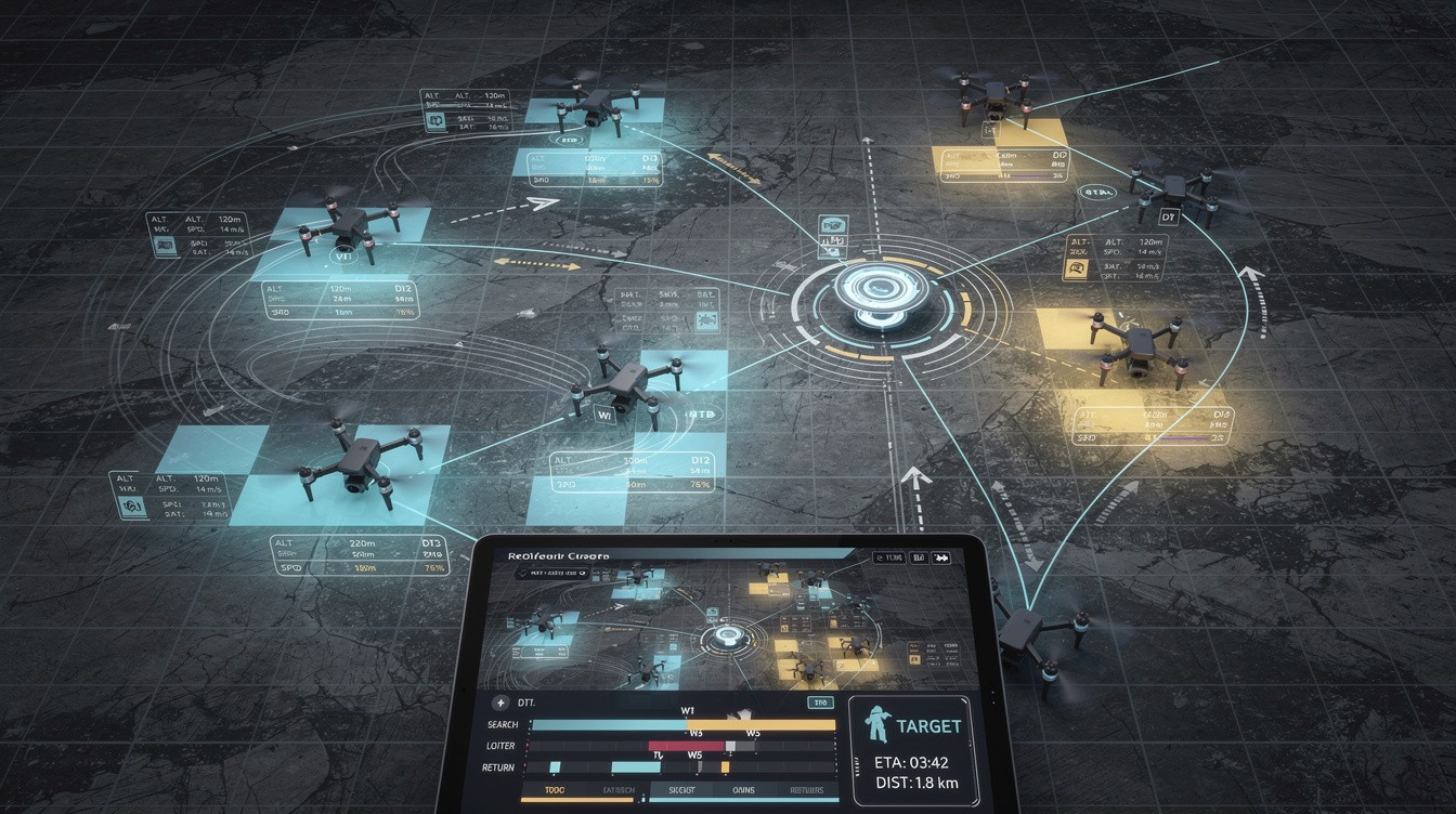
Modern multi-drone systems operate with decentralized control, meaning each drone makes tactical decisions based on local information while staying aligned with the overall mission. This approach prevents bottlenecks that plague centralized command structures, where communication delays or lost signals halt entire operations. According to research on Decentralized Multi-Agent Coordination, decentralized decision-making lets each drone act on local data while staying aligned with the mission, improving resilience in search operations where communication with a central controller may be unreliable. In practice, if one drone loses signal or encounters an obstacle, the remaining team members continue searching without waiting for central authorization. Task allocation based on drone capabilities and proximity optimizes coverage-a thermal-equipped unit focuses on heat detection while a high-resolution camera drone maps terrain simultaneously. Advanced collision avoidance and obstacle sensing prevent incidents when multiple drones operate in cluttered disaster environments (rubble fields, dense vegetation, or confined spaces). The result is continuous forward progress rather than stop-and-start operations that waste critical time when every minute affects survival outcomes.
Real-Time Communication Accelerates Response
Coordinated drones share information instantly across the team, eliminating the delays that single-drone operations introduce. When one unit identifies a potential survivor location, that data reaches ground control and other aerial assets in seconds rather than minutes. Real-time inter-drone communication and synchronization provide a shared situational picture that speeds decision-making during complex search-and-rescue scenarios. This immediate feedback loop allows rescue teams to position themselves strategically before a drone even completes its initial sweep. Multiple drones equipped with high-resolution and thermal cameras transmit overlapping data streams that ground teams cross-reference for accuracy. False positives decrease significantly when thermal and optical data confirm the same location simultaneously. The coordination infrastructure itself becomes a force multiplier-rescuers act on verified information rather than hunches, reducing wasted effort and accelerating victim recovery.
Understanding these operational advantages reveals why professional search-and-rescue teams increasingly rely on multi-drone deployments. The next section examines the technical systems that make this coordination possible, from communication protocols to flight planning software that orchestrates complex aerial operations.
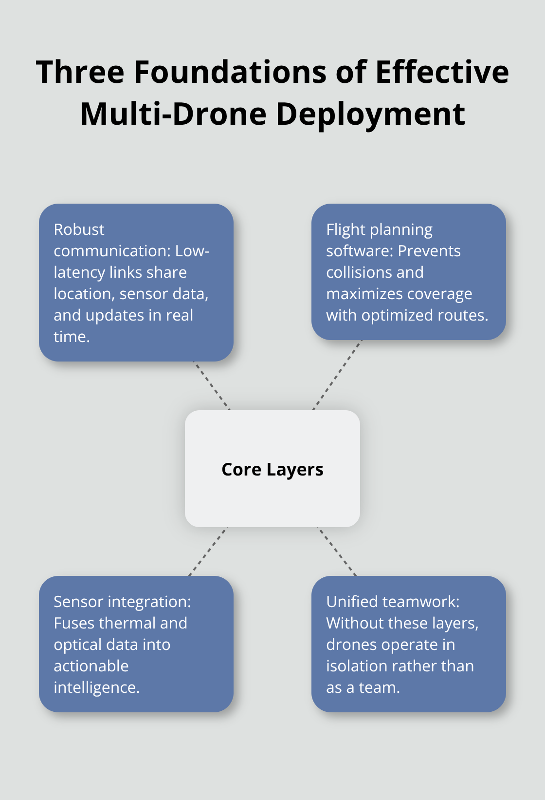
Technical Requirements for Effective Multi-Drone Deployment
Coordinated multi-drone systems require three foundational layers to function effectively in search and rescue: robust communication that transmits data without lag, flight planning software that prevents collisions while optimizing coverage, and sensor integration that combines thermal and optical data into actionable intelligence. Without these elements working seamlessly together, drones operate in isolation rather than as a unified team.
Communication Systems Enable Real-Time Data Sharing
Communication forms the backbone of coordinated operations-drones must exchange location data, sensor readings, and tactical updates in real time to maintain coordination. Standard radio frequencies used in commercial drone systems operate at 2.4 GHz and 5.8 GHz, with modern systems achieving update rates of 10 to 50 milliseconds between team members. A thermal detection on one drone reaches ground control and adjacent units in under one-tenth of a second, enabling rescue teams to respond while the discovery unfolds.
Network protocols must tolerate degraded signal conditions common in search scenarios. Mountains, dense forests, and disaster zones create dead zones where direct line-of-sight communication fails. Mesh networking, where drones relay signals through one another, extends effective range significantly. A drone with compromised signal transmits data through a teammate positioned higher or in clearer terrain, maintaining the data pipeline even when individual links drop.
Store-and-forward capability prevents data loss during temporary outages. Drones cache critical information locally and transmit when connectivity returns. A thermal signature recorded in a GPS-denied ravine gets stored on the drone’s onboard computer and uploads automatically once the unit climbs to higher elevation where signal returns.
Flight Planning Software Orchestrates Coverage
Flight planning software orchestrates the entire operation by computing GPS waypoint sequences, altitude profiles, and sensor actions while respecting battery constraints and airspace regulations. Modern mission planning generates routes that maximize area coverage while minimizing overlap-two drones searching the same location wastes battery and provides no additional information.
The software accounts for wind patterns, terrain elevation changes, and no-fly zones mandated by local aviation authorities. Real search operations involve dynamic re-planning: as one drone detects a heat signature, the system automatically adjusts remaining routes to concentrate coverage around that location while other assets continue scanning unexplored terrain.
Integrating Thermal and High-Resolution Cameras
Thermal and high-resolution cameras serve complementary functions that neither sensor achieves alone. Thermal cameras detect heat signatures with precision, but thermal images lack the detail needed for final victim confirmation and precise positioning. High-resolution optical cameras provide context-terrain features, clothing colors, identifying markers-that confirm whether a thermal detection represents a person or a false positive like heated rock or animal.
Ground control stations fuse both data streams, displaying thermal overlays on optical imagery so rescue teams see exactly where body heat appears within the surrounding landscape. This dual-sensor approach reduces false positives significantly and accelerates victim confirmation compared to thermal-only or optical-only searches.
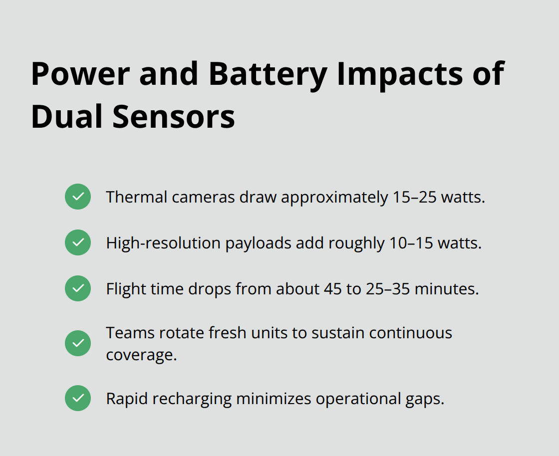
Thermal cameras consume approximately 15 to 25 watts of power, while high-resolution payloads add 10 to 15 watts, so multi-sensor drones require larger batteries that reduce flight time from 45 minutes to 25 to 35 minutes per battery cycle. Coordinated teams compensate by rotating fresh units into the search area while others return to base for rapid recharging, maintaining continuous coverage.
Rapid Charging Maintains Operational Continuity
The infrastructure supporting multi-drone coordination-redundant communication links, automated flight planning, sensor fusion software, and rapid charging stations-transforms scattered aerial assets into a cohesive system. Charging infrastructure becomes as important as the drones themselves. Fast-charging technology enables teams to maintain near-continuous search coverage by cycling fresh units into operation while others recharge. This rotation strategy prevents the operational gaps that occur when all drones return to base simultaneously for extended charging cycles. Ground teams position charging stations strategically within the search zone or at forward operating bases, reducing transit time and maximizing time drones spend actively searching rather than traveling to and from distant charging facilities.
The coordination infrastructure locates missing persons faster and more reliably than traditional methods. Understanding how these technical systems integrate with real-world search scenarios reveals where multi-drone deployments deliver the greatest impact-from mountain rescues to water-based searches and urban disaster response.
Real-World Applications in Search and Rescue
Mountain and Wilderness Rescues
Mountain and wilderness rescues demand speed that ground teams cannot match. When a hiker goes missing in terrain spanning thousands of acres with elevation changes exceeding 5,000 feet, coordinated drones cover the entire search zone in two to three hours while ground teams would require days to access the same areas. Thermal imaging excels in wilderness scenarios because missing persons often become immobilized from injury or exhaustion, making heat signatures the most reliable detection method. A thermal-equipped drone identifies a body heat signature in dense forest or rocky terrain where visual searches fail completely.
Multiple drones assigned to different elevation bands search simultaneously, with one unit scanning ridgelines while another covers valleys and dense vegetation below. Wind patterns in mountainous terrain can exceed 30 miles per hour at higher elevations, so coordinated teams adjust flight altitudes and routes dynamically to maintain stable thermal imaging while avoiding dangerous wind shear. The decentralized control approach proves invaluable here because individual drones adapt to local wind conditions without waiting for central command approval, maintaining search momentum even when conditions shift rapidly.
Water-Based Search Operations
Water-based searches present distinct challenges that multi-drone coordination handles more effectively than single-unit operations. Lakes, rivers, and coastal areas require thermal imaging to detect hypothermic victims who may be partially submerged or exhausted in the water. Thermal cameras identify body heat signatures even when victims float partially below the water surface, where visual cameras see only dark water.
Coordinated drones establish search patterns that sweep the water systematically while maintaining communication with rescue boats positioned to respond immediately upon detection. Battery constraints matter significantly in water rescue because drones cannot land on water for battery swaps, so teams rotate fresh units from shore-based charging stations in rapid cycles to maintain continuous coverage. A coordinated team searches a two-mile stretch of coastline in under 45 minutes with overlapping thermal coverage that eliminates blind spots. Single-drone operations require multiple passes and longer dwell times at each location, extending search duration when every minute affects victim survival.
Urban and Disaster Response Operations
Urban and disaster response situations showcase how multi-drone systems handle complex three-dimensional environments. Collapsed buildings, rubble fields, and dense urban areas create GPS-denied zones where traditional flight planning fails. Coordinated drones equipped with obstacle avoidance sensors navigate confined spaces and unstable debris while maintaining real-time communication about hazards and potential survivor locations.
High-resolution cameras map rubble patterns and identify access routes for ground rescue teams, while thermal imaging detects body heat signatures beneath debris. Coordinated multi-UAV systems in disaster zones accelerate survivor localization and support rapid casualty assessment compared to single-drone or ground-only searches. Disaster response teams position multiple drones at different heights and angles to create overlapping coverage that reveals survivors trapped in collapsed structures or hidden beneath debris.
One drone maps the disaster zone in high-resolution optical imagery while another focuses exclusively on thermal detection, and a third drone relays communication signals to ground teams in areas where direct radio contact fails. This parallel-processing approach compresses response times from hours to minutes, directly improving survival rates in time-critical scenarios. Rescue teams act on verified multi-sensor data rather than incomplete information from single sources, reducing false positives and wasted effort that delays victim recovery.
Final Thoughts
Multi-drone search coordination delivers measurable improvements that single-drone operations cannot match. Coordinated teams locate missing persons in hours instead of days, with thermal imaging detecting survivors in conditions where ground searches fail completely. Real-time data sharing between drones eliminates delays that cost lives in time-critical situations.
Modern technology transforms recovery outcomes by combining thermal detection with high-resolution mapping, obstacle avoidance with autonomous flight planning, and mesh networking with store-and-forward data protocols. These capabilities work together to compress search timelines dramatically across mountain rescues, water-based searches, and disaster response operations. The infrastructure supporting coordinated operations-rapid charging stations, communication networks, flight planning software, and sensor fusion systems-represents a significant investment that delivers returns measured in lives saved.
IE Drone Services stands ready to deploy coordinated aerial assets that accelerate recovery outcomes when minutes determine survival. Contact IE Drone Services to discuss how multi-drone search coordination can improve your organization’s search and rescue response capabilities.