
Mapping with drones has transformed how businesses understand their land, assets, and operations. From construction sites to agricultural fields, aerial data collection delivers precision that ground-based methods simply cannot match.
At IE Drone Services, we’ve helped hundreds of organizations capture accurate, actionable insights through drone mapping. This guide walks you through everything you need to know about the technology, its real-world applications, and how to choose the right provider for your needs.
How Drone Mapping Actually Works
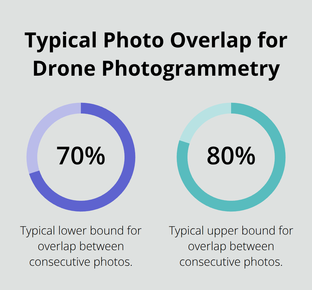
Drone mapping captures aerial imagery from an altitude, typically 100 to 400 feet, using high-resolution cameras mounted on aircraft. The drone flies a programmed grid pattern over the target area, taking overlapping photos-usually 70 to 80 percent overlap between consecutive images. This overlap is critical; it allows specialized software to stitch the images together using a technique called photogrammetry, which identifies matching points across photos and reconstructs a three-dimensional representation of the ground. The result is a digital twin of your site: georeferenced, measurable, and accurate to within 2 to 3 centimeters horizontally and around 5 centimeters vertically when executed properly. The entire flight over a typical construction site or agricultural field takes 10 to 30 minutes, and the data flows directly into cloud-based processing systems that generate orthomosaic maps, 3D models, and multispectral imagery within hours rather than days.
Ground Control Points Make the Difference
Accuracy depends entirely on ground control points, or GCPs. These are physical targets placed on the site-typically white and black crosshairs painted on tarps or the ground-that the survey team measures using GPS or RTK (real-time kinematic) positioning. A minimum of five GCPs distributed across the area is essential; larger sites benefit from 10 or more. Each target must be at least 75 centimeters wide and clearly visible in the drone imagery. The software uses these known coordinates as anchors, correcting for drift and ensuring that measurements from the final map reflect actual ground positions. Without GCPs, standard GPS provides drone positioning accuracy of 1–3 meters horizontally and 2–5 meters vertically, rendering them useless for construction planning or compliance. Ground control points remain the gold standard for survey-grade drone mapping.
From Raw Data to Actionable Maps
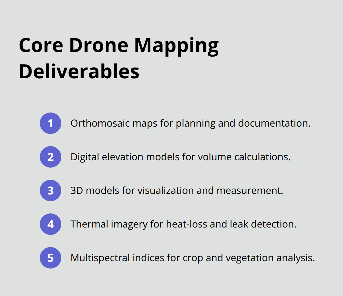
Processing transforms raw imagery into deliverables that drive decisions. The workflow imports drone images with embedded GPS tags into mapping software like DJI Terra or Pix4D, then overlays GCP data to refine accuracy. The software aligns thousands of images, identifies common features, and builds a point cloud-a dense mesh of three-dimensional coordinates representing every surface. From this point cloud, the system generates multiple outputs: orthomosaic maps for planning and documentation, digital elevation models for volume calculations, and thermal or multispectral data for specialized analysis. A construction team uses these maps to track progress against design plans, measure cut-and-fill volumes, and detect deviations early. Agricultural operations extract vegetation health indices from multispectral data to identify crop stress or pest damage. Mining operations measure stockpile volumes to quantify inventory and material movement.
The processing time varies with dataset size-small sites finish in hours, while large mining or corridor surveys may take 24 to 48 hours. Cloud-based platforms centralize this data, allowing owners, contractors, and engineers to view the same site model in real time, eliminating misalignment and reducing disputes.
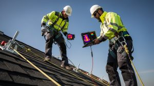
Why Professional Execution Matters
The difference between a useful map and a useless one comes down to execution. Flight planning must account for wind, battery life, and airspace regulations. The survey team must place GCPs strategically, measure them with precision, and mark them so they remain stable between sessions. The operator must maintain consistent altitude and overlap throughout the mission. Post-processing requires attention to detail-importing the correct coordinate system, verifying GCP positions, and validating the final output against known checkpoints. Weather sensitivity, equipment limitations, and regulatory constraints add complexity that inexperienced operators often underestimate. This is where professional expertise separates reliable data from expensive mistakes. The right provider brings not just equipment, but the knowledge to handle site-specific challenges, optimize workflows, and deliver maps you can actually trust for critical decisions.
Key Applications of Drone Mapping Across Industries
Construction teams track progress against design plans with precision that site walks cannot match. A typical commercial project deploys drone flights every 7 to 14 days to capture orthomosaic maps and 3D models, then overlays these against the original site plan to detect deviations in real time. Cut-and-fill calculations from drone-derived topography help earthworks crews balance materials on-site, reducing costly haul-offs and unnecessary imports. Progress documentation creates an auditable, time-stamped record that protects against disputes and supports change-order decisions.
Mining and Aggregates Benefit from Precise Volume Measurement
Mining and aggregate operations measure stockpile volumes to quantify material available for sale or movement since the last survey, turning inventory tracking from guesswork into precise measurement. A single stockpile survey takes 15 to 30 minutes by drone versus several hours with ground crews, and the data accuracy of 2 to 3 centimeters horizontally supports cost control and compliance reporting.
Landfill operators use drone surveys to verify slope stability, calculate remaining airspace, and monitor cell progress against design elevations-critical for operations that measure capacity in thousands of cubic yards.
Agriculture and Environmental Monitoring Leverage Multispectral Data
Agricultural operations extract vegetation health indices from multispectral drone imagery to monitor crop health, track growth patterns, and optimize farming efficiency. Farmers apply this data to targeted pesticide or fertilizer applications, reducing chemical use and protecting yield. Environmental monitoring teams use drone mapping to assess erosion, wetland changes, or habitat conditions across large areas, delivering baseline data and change detection that ground surveys cannot achieve in the same timeframe.
Frequency Transforms How Organizations Make Decisions
The real advantage of drone mapping lies in frequency. Traditional land surveying takes days or weeks and costs thousands per deployment; drone missions complete in hours and cost a fraction of ground surveys. Construction teams update site models weekly instead of monthly, catching problems before they cascade into schedule delays. Agricultural operations monitor crop health throughout the growing season, not just at planting and harvest. Infrastructure teams inspect bridges, power lines, and communication towers without closing roads or disrupting service.
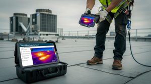
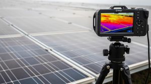
Thermal and Multispectral Data Reveal Hidden Problems
The 2026 industry trend emphasizes rapid, reliable data delivery over complex modeling-operators want maps they can trust for decisions within hours, not days. Thermal and multispectral data from drone sensors add another dimension: building inspectors detect roof leaks and energy loss from infrared imagery, solar installers identify panel defects before installation, and agricultural advisors pinpoint water stress invisible to the naked eye. This multi-layer approach transforms drone mapping from a novelty into an operational necessity for organizations that compete on efficiency and data-driven decisions. The question shifts from whether to use drone mapping to which provider can deliver the speed, accuracy, and expertise your operation demands.
Choosing the Right Drone Mapping Service Provider
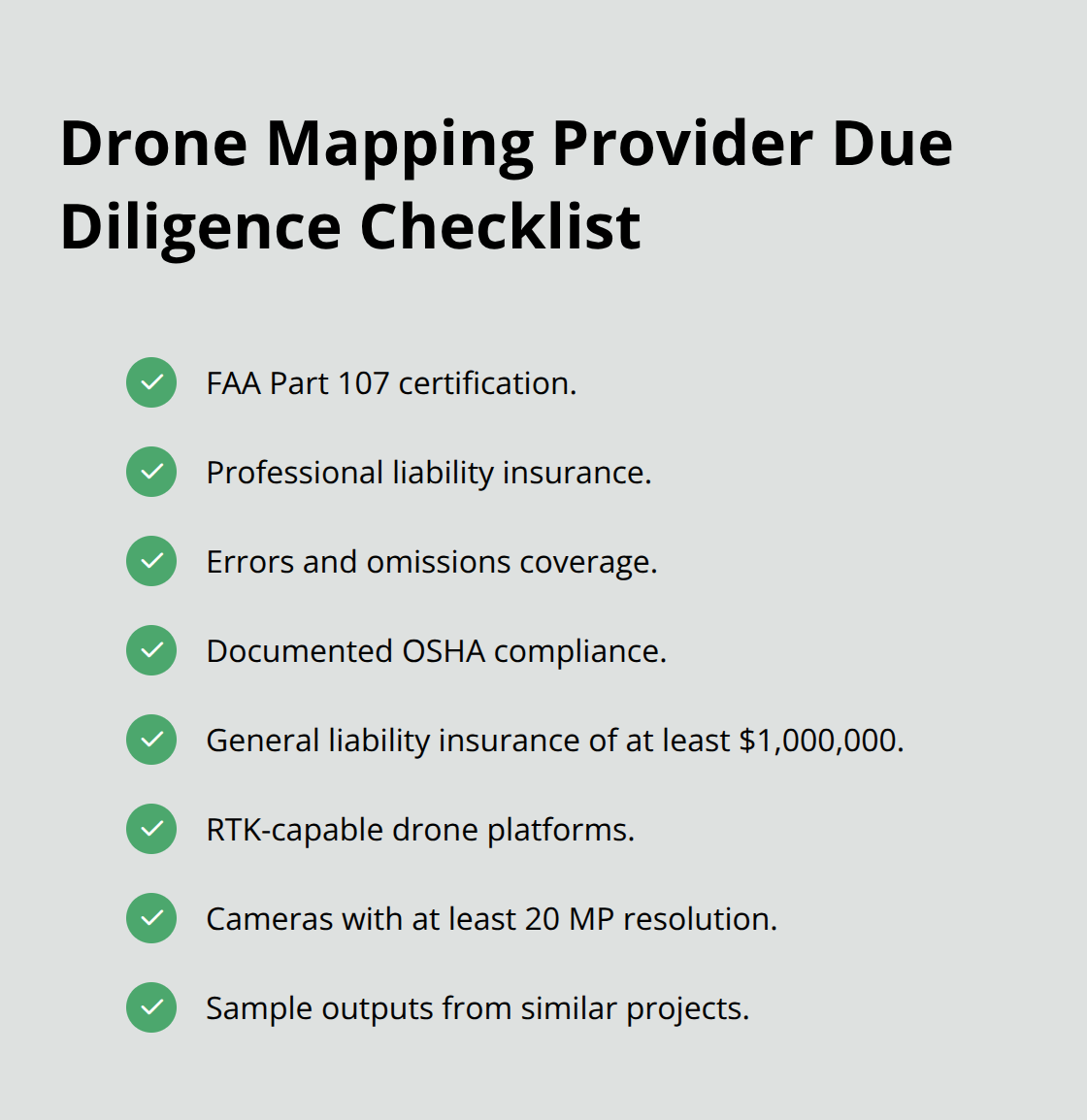
Drone mapping demands more than a pilot license. The provider must hold an FAA Part 107 certification, which requires passing an aeronautical knowledge test and demonstrating competency in flight operations, airspace rules, and safety procedures. However, Part 107 alone does not qualify someone to conduct surveys. Look for providers who also carry professional liability insurance, errors and omissions coverage, and documented proof of OSHA compliance on active job sites. Ask directly whether the company carries general liability insurance with minimums of at least one million dollars; this protects you if equipment damage or injury occurs during operations.
Regulatory Knowledge Protects Your Project
Beyond insurance, verify that the provider understands the specific regulatory requirements of your industry. Construction firms operating near airports need proof of airspace authorization through LAANC or manual FAA approval. Mining operations in certain states require coordination with state geological surveys. Real estate transactions may involve privacy compliance depending on your jurisdiction. A competent provider knows these requirements before you ask and incorporates them into the project scope.
The provider should also document how they handle data security, especially if your site contains proprietary information or competitive intelligence. Ask whether they use encrypted cloud storage, maintain data retention policies, and can sign non-disclosure agreements. This matters because your drone maps reveal site conditions, progress timelines, and operational details that competitors would pay to access.
Equipment Quality Determines Data Reliability
Professional drone mapping requires cameras with at least 20 megapixel resolution and RTK (real-time kinematic) positioning capability to achieve survey-grade accuracy for construction and mining work. Standard GPS-only drones deliver 1 to 3 meter positional error, making them unsuitable for anything beyond preliminary site assessment. Ask the provider which specific aircraft and camera platforms they operate. DJI Phantom 4 RTK, Matrice 300 RTK, and Mavic 3 Enterprise represent current industry standards; providers using older platforms like the original Phantom 4 Pro lack the RTK capability essential for survey-grade work.
Equally important is the processing software. DJI Terra, Pix4D, and Correlator3D are production-grade platforms that handle large datasets reliably and deliver orthomosaics and 3D models within predictable timeframes. Cheap or outdated software introduces processing errors that corrupt your final deliverables. Ask the provider to show you sample outputs from similar projects-not generic examples, but actual work they completed for clients in your industry. Examine the orthomosaic clarity, the completeness of 3D models, and whether multispectral or thermal data matches your actual needs. A provider who hesitates to share samples or shows work from significantly different project types should raise a red flag.
The equipment investment alone separates serious operators from hobbyists. Professional-grade drones, RTK base stations, ground control point targets, and processing software represent a capital outlay of thirty to fifty thousand dollars minimum. Providers who operate below this threshold cut corners somewhere, whether through outdated equipment, insufficient training, or unreliable post-processing workflows.
Industry-Specific Experience Outweighs Generic Portfolios
A provider with industry-specific experience in real estate photography cannot reliably execute a mining stockpile survey. The workflows differ fundamentally. Real estate flights optimize for aesthetics and quick turnaround; mining surveys demand precise volumetric accuracy and frequent repeat flights to track material movement. Construction progress tracking requires consistent flight parameters and GCP placement across multiple missions spanning months; agricultural multispectral analysis demands knowledge of vegetation indices and crop-specific interpretation.
Ask the provider for references within your industry and contact them directly. Specifically ask whether the provider delivered maps within the promised timeframe, met accuracy requirements, and responded effectively to site-specific challenges. Ask whether the provider has handled projects at the scale you need. A provider experienced with five-acre agricultural fields may struggle with a two-hundred-acre mining operation. Ask how they scale processing workflows and manage data bottlenecks when dataset sizes grow.
The provider should explain their quality assurance process explicitly. Do they validate GCP positions before processing? Do they compare final outputs against independent ground truth measurements? Do they have a process for flagging questionable results and communicating limitations to clients? A provider who claims expertise everywhere probably has expertise nowhere.
Final Thoughts
Mapping with drones transforms how organizations collect, analyze, and act on site data. Construction teams detect schedule deviations weeks earlier, mining operations quantify inventory with centimeter-level precision, and agricultural advisors optimize resource use based on real vegetation health data. The speed advantage alone justifies adoption-a drone survey completes in hours where traditional methods require days or weeks, and the cost per acre drops dramatically as site size increases.
Technology alone does not guarantee success. The difference between a map that drives confident decisions and one that sits unused comes down to execution quality. Professional expertise means understanding your specific industry, managing site-specific challenges, maintaining consistent workflows across multiple missions, and delivering outputs you can actually trust. It means knowing which equipment platform suits your accuracy requirements, which processing software handles your dataset size reliably, and how to validate results against ground truth.
We at IE Drone Services bring this expertise to construction, real estate, and infrastructure projects across the Inland Empire. Our FAA-certified team operates professional-grade platforms with high-resolution and thermal cameras, delivering the precise, actionable data your operation needs to make faster, smarter decisions. Contact IE Drone Services to discuss how mapping with drones can improve your next project.