IE Drone Services & Inspection

Pinpoint Subsurface Leaks with Unmatched Precision. Save Time, Money, and Resources.
Suspecting a leak in an underground hydronic, steam, or water line can lead to costly and destructive exploratory digging. IE Drone Services offers a non-invasive, fast, and highly accurate solution. Using state-of-the-art DJI thermal drones, we identify subsurface leaks with pinpoint accuracy, saving you from expensive and unnecessary excavation.
Our advanced thermal imaging services are designed for municipalities, universities, commercial properties, and industrial facilities across the Inland Empire and Greater Los Angeles area.
The Challenge: Invisible and Costly Leaks
Leaks in underground pipes are notoriously difficult to locate. Traditional methods often involve educated guesswork and extensive digging, leading to:
High Excavation Costs
Unnecessary trenching and landscape destruction.
Wasted Resources:
Significant loss of water, energy, and money.
Extended Downtime
Prolonged service interruptions for your facility or community.
Property Damage:
Damage to surrounding infrastructure, landscaping, and pavement.
Our Solution: Advanced Aerial Thermal Imaging
IE Drone Services turns a complex problem into a clear solution. Our DJI Mavic Enterprise drones are equipped with high-resolution x radiometric thermal cameras that detect minute temperature differences on the ground surface caused by subsurface leaks. This allows us to:
01
Visualize the Leak
See the heat signature of a hot water or steam leak as it warms the ground above.
02
Map the Entire System
Quickly survey large areas and long stretches of pipeline, creating a comprehensive thermal orthomosaic map.
03
Pinpoint the Exact Location
Provide precise GPS coordinates of thermal anomalies, guiding your repair crews to the exact point of failure
Applications for Thermal Leak Detection
Our services are critical for the maintenance and integrity of a wide range of underground utility systems. We specialize in:
University and College Campuses:
Locating leaks in complex campus-wide hydronic heating and cooling systems.
Municipal Water Systems
Identifying leaks in municipal water mains and distribution lines.
Commercial Properties
Detecting slab leaks and issues in plumbing for large commercial buildings and shopping centers.
Industrial Facilities
Pinpointing leaks in steam pipes and process water lines.
District Energy Systems:
Surveying large-scale heating and cooling networks for inefficiencies and leaks.
Our Proven Process
Consultation & Planning
We start by understanding your specific needs, reviewing site plans, and determining the optimal time for the thermal survey (typically early morning or late evening for best thermal contrast).
Aerial Survey
Our FAA Certified pilot conducts the flight, capturing high-resolution thermal and visual data of the entire target area.
Data Processing & Analysis
We process the collected imagery to create a detailed thermal orthomosaic map. Our experts analyze the data to identify and measure thermal anomalies, cross-referencing them with visual data.
Comprehensive Reporting
You receive a professional, actionable report that includes the full thermal map, detailed close-ups of anomalies, precise GPS coordinates, temperature measurements, and clear recommendations for your ground crews.
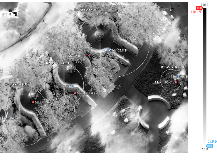
Case Study: Cal State San Bernardino Hydronic Leak
Challenge
Cal State San Bernardino suspected a leak in an -foot section of their underground hydronic system but were unsure of the exact location.
Action
IE Drone Services conducted a thermal survey and created a full orthomosaic map of the area.
Result
We identified a primary anomaly with a temperature of °F—a °F differential from the surrounding ground. We provided the client with a detailed report, including the thermal map and precise GPS coordinates. This allowed their maintenance team to avoid exploratory digging and go directly to the source of the problem, saving significant time and money.
Why IE Drone Services?
Reduce Costs Dramatically
Avoid thousands of dollars in unnecessary excavation and repair costs.
Act Quickly and Precisely
Our rapid deployment and accurate data allow you to fix problems faster.
Non-Invasive & Safe
We inspect your entire system without any disruption to your property or operations
Actionable, Professional Reports
We provide clear, comprehensive reports that your maintenance teams can use immediately.
FAA Certified and Insured:
All operations are conducted safely and professionally by licensed pilots.
Ready to Find Your Leak?
Stop guessing and start seeing. Contact IE Drone Services today for a free consultation and quote for our Underground Thermal Leak Detection services. Let us help you save time, money, and resources.